Bringing your projects to life through 3D digitalization

3D Scanning, Surveying & BIM – Precision at the core of every project

ARTOP specializes in 3D scanning, land surveying, drone-based data collection, and BIM modeling. Operating across Canada, France, Poland, Morocco, Qatar, and Congo, our team provides high-precision solutions for infrastructure, construction, and mobile mapping projects.

Delivering your vision

28 ans d’expertise ininterrompue

For nearly three decades, ARTOP has partnered with clients on complex infrastructure, surveying, and BIM modeling projects, delivering industry-leading precision and reliability.

1000+

Projects successfully delivered worldwide

28+

Years of proven track record

400+

Satisfied clients across public & private sectors.

120+

Experts worldwide

Our Services

Comprehensive geospatial expertise: From field data to Digital Twins.

Modélisation BIM pour une gestion intelligente des projets de construction.

BIM Management & Coordination

We streamline BIM coordination across all project stakeholders to detect clashes, harmonize models, and ensure seamless on-site execution.

Scanner 3D terrestre et mobile en action, capturant des données précises et détaillées pour la modélisation et l'analyse des environnements complexes.

3D Laser Scanning


Rapid point cloud acquisition for both indoor and outdoor environments, providing high-fidelity data for modeling and quality control.

Captures aériennes par drone pour une cartographie 3D précise, rapide et géoréférencée

UAV / Drone Surveys


Specialized LiDAR and photogrammetric data capture using advanced multi-rotor and fixed-wing UAV platforms.

Maquette numérique 3D d’un bâtiment pour modélisation BIM et coordination des données.

BIM Modeling (Scan-to-BIM)


Developing and updating precise Building Information Models (BIM) directly from high-accuracy field survey data.

Analyse volumétrique d’une carrière pour le calcul de matériaux extraits via drone et modélisation 3D.

Volumetric Analysis


Accurate earthwork calculations for cut, fill, and stockpile volumes using drone surveys, 3D scanners, or total stations.

Carte d’analyse de la planéité d’un dallage en couleurs, montrant les écarts de niveau sur une dalle béton.

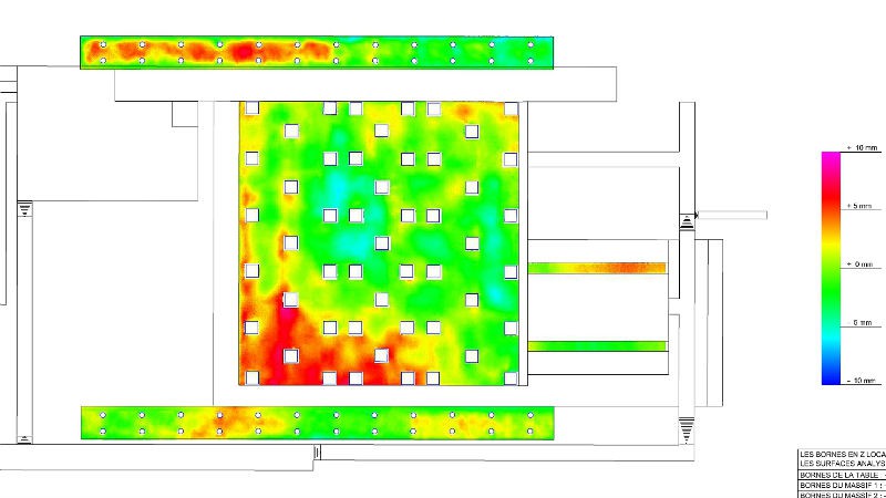
Floor Flatness & Levelness Analysis

High-precision surface surveys to detect millimeter-level deviations in concrete slabs, ensuring structural compliance and optimizing corrective workflows.

Relevés TQC pour documenter la construction finale avec exactitude.


As-Built Surveys

Delivery of precise As-Built (TQC) surveys to ensure project compliance and data integrity throughout every construction phase.

Relevés topographiques de haute précision pour vos projets de construction et aménagement.


Topographic Surveying

Reliable and precise topographic data collection, essential for strategic project planning and field operation optimization.

Capteur d’auscultation installé pour le suivi structurel d’un ouvrage d’art.

Structural Health Monitoring

Real-time infrastructure monitoring solutions providing critical data for safety, precision, and rapid response across all projects.

Cost Calculator

Estimate your savings with Artop Geomatics

sq. ft
or
sq. m

Slide to adjust the area

Cost Comparison

Traditional Method
(3-person crew)
Mobilization: $4,500
Survey: $0
Total: $0
Artop Solution (3D)
(1 Specialized Expert)
Mobilization: $1,500
Survey: $0
Total: $0
TOTAL ARTOP
SOLUTION*
$0
YOUR ESTIMATED
SAVINGS*
$0

Sustainability & Safety

Committed to Safe, Responsible, and Sustainable Operations

At ARTOP, we uphold the most rigorous field safety and sustainable development standards. Our teams operate with integrity and precision on every project, across the globe.

Our Daily Commitments

Our Recent Project Portfolio

Ouvrir le chat
Des questions?
Scan the code
ASSISTANT VIRTUEL - ARTOP
Bonjour 👋
Pouvons-nous vous aider?